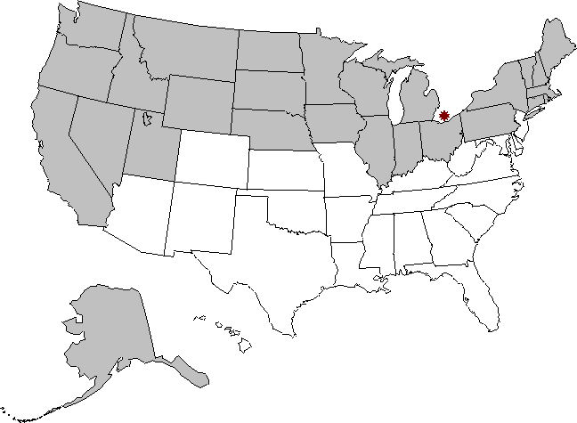
Map of U.S. States North of Canada If you have no idea how you got here, back up to the previous page. If you do, these are the 27 U.S. states at least partly north of the southernmost part of Canada.
*The 13 states marked with an asterisk are entirely north of Canada's southernmost point of land. Go straight down to here to see the evidence.
November 22, 2020: Today I received an email from an organization called Three Interesting Things. The gist of the mail was that part of the podcast named Three Interesting Things had to do with how many U.S. states are at least partly north of Canada's southernmost point. You can and should listen to that podcast at https://threeinterestingthings.captivate.fm/, where you must find the episode published on November 17, 2020, titled, I swear, "Comb Your Gums." The First Interesting Thing ends at approximately 11:55. |
|
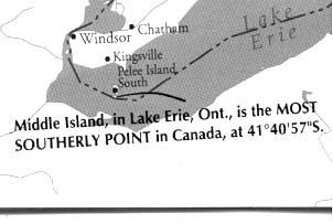
The southernmost point of Canada is in Lake Erie on a now-uninhabited island called Middle Island, which is part of Pelee Township, which is part of the province of Ontario (which should not be confused with the nearby Middle Bass Island, which is part of Ohio). Although always a part of Canada, Middle Island was until 2000 owned by an Ohio car dealer who bought it as a pleasure island for his family. After his death his heirs sold it by outcry auction. A non-profit agency called The Canadian Nature Conservancy, which had publicly raised funds for the purpose, bought it for roughly U$867,000 and then deeded it to Canada. You can read more HERE and HERE and HERE and HERE. In any case, the question is how many U.S. states are at least partly north of some part of Canada, and I hereby declare as follows: The southernmost point of Middle Island, Ontario, Canada, This is the same as a latitude of 41.68138 degrees north. If you have any reason at all for even remotely, possibly, maybe thinking that I might even remotely possibly might be wrong about this exact point, please immediately. It's because of people like you that I have been able to narrow down that exact latitude to a pretty high degree of accuracy with a pretty high degree of confidence, as you'll see below. If you find yourself wandering around on Middle Island or approaching it from Lake Erie, and if you have a GPS unit that can tell you latitude and longitude, please go ahead and locate that southernmost point and let me know what your numbers are, and do take a photo or two, and thanks. If you're in charge of at least three secret, high-altitude spy planes and you can get them to photograph and triangulate the position, feel free. Same if you have the power to alter the orbits of imaging satellites or the International Space Station: Just go ahead and get 'er done and get me the results ASAP, and -- again -- thanks.
Four sources. Below are the
four sources I used to arrive at that latitude of
41d 40m
53s. |
|
Using FLASHEARTH.COM, I placed my cursor on the point I thought best represented the southernmost point of Middle Island, not counting the (light-colored) beach. Thanks go to of Stockbridge, Wisconsin, for bringing this resouce to my attention, as well as for corrections and additions and other improvements to this page. However, I am responsible for any errors, not Ken or anyone else who has helped with this little project. You can see the exact spot I chose HERE.
The result is coordinates of 41d 40m 53s,-82d 41m 2s, which
translates to |
| Google Maps If you assiduously use Google Maps you will likely end up with a depiction that looks a lot like the one HERE. To check this point yourself using Google Maps, copy the below, go to Google MAPS, and paste it into the Search Maps text box at the top. 41.681461,-82.683632 That latitude of 41.681461 translates to 41d 40m 53.2596s. |
All of the four sources above agree that the number of degrees north is 41 and that the number of minutes is 40. As to the number of seconds, one source says 53, another says 53.2596, another says 53, and the fourth says 53.119. The average, for what it's worth, is 53.09465 seconds, which is less than 10 feet north of the even 53-second latitude I chose. Even the northernmost point of the four is less than 27 feet north. I am confident that 41 40 53 North is the nearest second of the southernmost point of Canadian land. The exact point of Canada's southernmost point of land surely can never be known unless it is declared by fiat, as with, say, Nevada's northern border. The exact point on Middle Island will surely vary by a little as geologic erosion or build-up takes place or the surrounding waters rise or fall. The exact point will surely vary by the season and by which satellite took which photo or by exactly where on the beach you stand when you take your GPS reading and by the precision of your GPS unit, or by rounding error, or just by exactly where you click your mouse. Based on the evidence presented above, it can confidently be said that the exact
latitude
of Canadian land that is southernmost is much closer to 41d 40m 53s than
any other second. This translates to exactly 41.68138
degrees north. If you disagree with that latitude, or if you can confirm that
it is correct, or if you can confer additional precision, I really
do hope you will
.
Canadian waters versus land. All along I have been referring to the 27 states' being north of the southernmost point of Canada's land, but the argument has been made more than once that I should include her waters as well. My response is that this was originally presented as a bar bet, and the loser might well argue that he thought it referred only to the land. "Hey, now, you didn't say the waters. I thought you meant the land. If I'd known you were including the waters as part of Canadian territory, I wouldn't have made the bet, so I'm not paying." You don't want to have to argue such a technicality, and you can avoid the problem by phrasing the bet so it refers only to the land parts of Canada. But what if we do include Canadian waters as well? Does that extend the bet far enough south to add a 28th state? According to both HERE and HERE, the latitude of the border southeast of Middle Island is 41d 40m 36s, which is exactly 17 seconds south of the point on Middle Island that I chose (41d 40m 53s), which means it is less than 574 yards south, which means the distance from there to the northernmost point of New Jersey's land, as you will see, is still less than 22.08 miles, so still no 28th cigar. Whew. To repeat, the latitude of the southernmost point of Canada's waters is at 41 40 36, which is exactly the same as 41.676. Also, go HERE for some useful information on U.S. state borders.By studying the map and the list at the top of this page and the table below, you can see that no U.S. state not mentioned below is even close to being close. Indeed, I probably needn't have included Nebraska (91.03 miles north) and Missouri (73.76 miles south) at all, but I want there to be no doubt. I want this to be the last word on the subject, so you and I can move on. The table below lists the distance south in statute miles from each of the nine latitudes in question to every other. For example, the distance south from the northernmost point of Indiana to the southernmost point of Canada is 5.44 statute miles, and the distance north (a negative number) from the northernmost point of New Jersey to Canada is 22.40 statute miles. The links in the first column are to Mapquest or Google Maps or some other source using the degrees, minutes, seconds format (DDMMSS). In some cases the corresponding headings in the top row link to equivalent maps in the decimal degrees format. Feel free to click any of the 18 links. Two notes on precision: (1) In the table below the numbers are shown rounded to two decimal places, but in the spreadsheet (see below) that informs this table and in other calculated results, full precision is used till the last possible moment. (2) Numbers with a line, called a macron, over them are repeating decimals, e.g., 7.3 means 7 and one third. |
|
|
|||||||||||||||||||||||||||||||||||||||||||||||||||||||||||||||||||||||||||||||||||||||||||||||||||||||||||||||||||||||||||||||||||||||||||||||||||||||||
|
|||||||||||||||||||||||||||||||||||||||||||||||||||||||
Hawaii: I don't list Hawaii in either table above, but I should have according to this e-mail exchange, listed in reverse chronological order: February 16, 2003 -- Hey Johnny. Thanks for replying. I found myself there because I was looking around to see where I could find accurate measurements of places and I also was curious to see if people thought that New Jersey was one of the 28 states when it is actually not. Sure, you may quote me if you like, but it was no problem at all. --Katherine February 15, 2003 -- Dear Katherine. Thanks for your kind words about that Web page. May I ask, how did you find yourself there? Also, may I quote you about Hawaii? Thanks. --Johnny February 14, 2003 -- Hi Johnny G. My name's Katherine Dover. I am a student at the University of Western Ontario in London. I study Canadian history and geography, and your north_of_canada_map.htm page [this very page] is very accurate to my knowledge. There is indeed just one minor problem though. That is that you forgot the state of Hawaii. All of the islands there are over 41 degrees north which allows it to qualify as one of those states that are at least partially north of Canada's most southerly point. Therefore, this makes your final total actually 28 states. Feel free to email me back if you have anything to say. Sincerely. --Katherine Dover [not her real name] This is a useful example for showing how to calculate the distance north and south from one latitude to another. Assume the northernmost part of Hawaii is at 29 degrees north and Canada's southernmost point is at 41 degrees north, a distance of 12 degrees. What is that distance? If you were to look at a map of Hawaii and guess at its northernmost unit degree of latitude, you'd probably say 23 degrees North. But you'd be wrong. It turns out that a part of Hawaii exists as far north as 29 degrees, a distance of another 400 miles. Kure Atoll and the other Northwestern Hawaiian Islands are technically part of the city of Honolulu, even though they're located some 1,300 miles away. See HERE for more information, and give credit to Dan Haigh for bringing this to my attention. One minute of arc, a 60th of a degree, is defined as 1,852 meters in length. Said another way, if you travel north (or south) from wherever you are now till you've changed latitude by exactly 1 minute, you will have traveled exactly 1,852 meters, or just over a mile. If you travel a full degree of distance, or 60 minutes, that's simply 1,852 meters times 60 degrees per minute, or exactly 111,120 meters, which is about 69 statute miles. So if Hawaii is at 29 degrees north and Canada is at 41 degrees north, dear Katherine was off by well over 800 miles, which is why I didn't use her real name. |
Thirteen U.S. states entirely north of Canada's southernmost point If you were surprised that as many as 27 U.S. states are north of Canada's southernmost point, you might also be surprised to learn that 13 of those 27, more than a quarter of the 50, are entirely north thereof. Let's look at the southernmost points of those 13 plus the nearest contenders for 14th and compare them to the latitude of 41 40 53 that I declared above is the southernmost point of Canada's land. So you don't have to keep scrolling up and down, here again is the map at the top of the page.
The U.S. states listed below are listed in order from the northernmost southernmost point to the southernmost southernmost. No state not listed below is even close to being close.
|
Alaska's southernmost point is on Amatignak Island. The southern tip of that island, in the Bering Sea and a part of the Aleutian Islands, is called Nitrof Point. Paste these coordinates into a mapping service such as Google MAPS, to see approximately where it is. 51.219444,-179.1213889 51.2194 minus 41.68138
degrees is 9.53805 degrees, which
is 658.5718984 statute miles. |
Alaska 51.2194 > 658 miles |
| We know all of North Dakota is entirely north of Canada's
southernmost point because it is entirely north of South Dakota, which
we see later is one of the 13 states entirely north of Canada's
southernmost point. Still, to confirm North Dakota's southernmost point, copy the below, go to Google MAPS, and paste it into the Search Maps text box at the top. 45.935249,-96.563683 North Dakota's southernmost point at 45.935249 minus 41.68138 is a whopping 4.2538601 degrees, which is 293.7152874 miles. |
North Dakota 45.935249 > 293 miles |
| We know all of the state of Washington is entirely
north of Canada's southernmost point because it is entirely north of
Oregon, which is itself one of the 13 states. In case you're interested, the southernmost point I chose
for Washington is
HERE. To confirm Washington's southernmost point, copy the below, go to Google MAPS, and paste it into the Search Maps text box at the top. 45.54835,-122.3 45.54835 minus 41.68138
degrees is 3.866961,
which is 267.0011624 miles north enough. |
Washington 45.54835 > 267 miles |
| We know all of Montana is entirely north of Canada's
southernmost point because its southernmost point is well north of
Idaho's southern border and we know Idaho is one of the 13 states. To confirm Montana's southernmost point, copy the below, go to Google MAPS, and paste it into the Search Maps text box at the top. 44.358221,-112.844865 44.358221 minus 41.68138
is 2.6768321, which is
184.8266028 miles far enough north. |
Montana 44.358221 > 184 miles |
| Minnesota's southernmost point might or might not lie on a straight
east-west line, but it is surely not much south of 43.5 degrees, which
puts it north of Canada's southernmost point by over 125 miles, and I
know I'm not off by that much. But by how much I am off is mildly interesting. HERE is Flashearth's picture of the western end of Minnesota's southern border with Iowa and South Dakota. Note that the dashed line representing that border point I chose lands exactly on the intersection of two roads, those being named 100th Street east and west and 10th Avenue north and south. HERE is the Google Maps' version of that intersection of two dashed lines, which certainly represent the border. You'll see that it is well southeast of the intersection of those two roads. One of those sources must be wrong, regardless of what latitude and longitude numbers are involved, by at least a little bit. And even if you don't expect Google and Flashearth to match up perfectly, there's definitely a problem in Flashearth alone. Note that when you click the Latitude and Longitude section just under //Location, you toggle from the smart decimal to the stupid minutes format. The latitude you remember from HERE in decimal is 43.500388, which is extremely close to Google's 43.500366, which is reassuring. But that's not the point. The point is that Flashearth converts 43.500388 to 43d 30m 1.3s. One of those numbers must be wrong, because 43.500388 converts to exactly 43d 30m 1.3968s, which obviously cannot round to 43d 30m 1.3s. Maybe Flashearth is merely deleting more and more significant digits from the right to get it down to tenths of a second, but obviously that's going to cause inaccuracies pretty close to half the time. If you can explain either of these contradictions, please
.
|
Minnesota ~43.5 > 125 miles
Minnesota ~43.5 > 125 miles
|
| To confirm Maine's southernmost point for yourself,
copy the below, go to Google
MAPS, and paste it into the Search Maps
text box at the top. 42.974708,-70.599014 At a latitude of 42.974708 degrees north, Maine's southernmost point
of land is 89.2995032 miles north of Canada's southernmost point, by
1.2933191 degrees, which
is over 89 statute miles. |
Maine 42.974708 > 89 miles |
| The spot I chose for Vermont is
HERE, which is the easternmost point of the border between Vermont
and Massachusetts to the south, which is not a line of latitude as it
appears but which rather slopes slightly south as it moves east. To confirm Vermont's southernmost point for yourself, copy the below, go to Google MAPS, and paste it into the Search Maps text box at the top. 42.726854,-72.458442 Vermont's most southerly point at 42.726854 minus Canada's at 41.68138
means Vermont is on the list of 13 states by 1.0454651 degrees, or over
72 miles (72.1859858). |
Vermont 42.726854 > 72 miles |
Go HERE to see the point I chose for New Hampshire. It is at the east end of the straight line that defines most of Vermont's and New Hampshire's southern boundaries, where New Hampshire meets Massachusetts and their border veers north. To confirm New Hampshire's southernmost point for yourself, copy the below, go to Google MAPS, and paste it into the Search Maps text box at the top. 42.696990, -71.294208 New Hampshire's 42.69699 minus Canada's 41.68138
puts New Hampshire on the list of 13 states by a distance of
1.015601 degrees, which is over 70 miles (70.1239732.). |
New Hampshire 42.69699 > 70 miles |
Wisconsin's southern border's two endpoints can be seen HERE in Google Maps, as well as the most southerly point I could find, which is in Lake Michigan. The border moves north or south a tiny bit every so often, especially at the far west end, perhaps following markers, sometimes called monuments, set in the ground by surveyors in the field. The border is generally at almost exactly 42.5 degrees, but there are variations. That lowest point I found is within 0.00828 degrees of 42.5, which is a mere 57.17072% of a statute mile. No matter which marker you choose, Wisconsin's southernmost point is
more than 56 miles north of Canada's. |
Wisconsin 42.49172 > 56 miles |
Go HERE to see Google Maps' representation of where I think South Dakota's southernmost point is, where it intersects with Nebraska in the middle of the Missouri River (and just a touch west of where it intersects with Iowa). To confirm South Dakota's southernmost point, copy the below, go to Google MAPS, and paste it into the Search Maps text box at the top. 42.47969,-96.479989 Go HERE to see the same point in Flashearth, which reports a latitude of 42.479641, which is south by less than 18 feet from the point I chose using Google Maps. The
latitude I chose, 42.47969, minus Canada's 41.68138
means South Dakota is on the list of 13 states entirely north of
Canada's southernmost point by 0.798301 degrees, a distance of 55.1201107 miles. |
South Dakota 42.47969 > 55 miles |
We know all of Idaho is entirely north of Canada's southernmost point because its southern border is the same as Nevada's and Utah's northern borders, which we already know are all defined to be exactly 42 degrees north, which we know is well north of Canada's southernmost point. 42 degrees minus 41.68138
degrees is 0.31861
degrees, which is 21.9990671 miles. |
Idaho 42.00 > 21 miles |
We know all of Oregon is entirely north of Canada's southernmost point because its southern border is the same as Nevada's and California's northern borders, which we already know are all defined to be exactly 42 degrees north, which we already know makes them among the 27 states. Again, 42 degrees minus 41.68138
degrees is 0.31861
degrees, which is still 21.9990671 miles. |
Oregon 42.00 > 21 miles |
I have no idea where Rome's southernmost point is. If you do, please . The spot I chose, more or less at random, is at the south end of what looks like a ring road around Roma. If this latitude is correct, which I doubt, then all of Rome is north of Canada's southernmost point by 41.792059 minus 41.68138, which is 0.1106701 degrees, which would make all of Rome north of Canada's southernmost point by a distance of 7.6414134 miles. To confirm where I chose for Rome's southernmost point for yourself, copy either of the below, go to Google MAPS, and paste it into the Search Maps text box at the top. 41.792059, 12.510443 Perhaps of more interest is where
Canada's southernmost latitude at 41.68138
lies with respect to Rome. Go
HERE to see the point I chose as well as where Canada's latitude
is with respect to the general area. |
Rome, Italy 41.792059? > 7.6 miles? |
With Michigan we have to slow down and be extra careful, because it's close. In fact it's by far (har) the closest measurement on this whole page relative to Canada's southernmost point. First, note that we're concerned only with the Lower Peninsula, because the Upper Peninsula of Michigan is entirely north of, and thoroughly separated from as far as that goes (re-har), the Lower. The three south border lines of Michigan, which are straight, are the same as the northern borders of Indiana and Ohio. If you go HERE you'll see what I mean. From the west, the southern border of Michigan starts in the middle of Lake Michigan where it intersects with Illinois and Indiana. It travels east till it arrives on land, where it towels off and exchanges a swim suit for walking clothes and proceeds straight east, i.e., it follows a line of latitude as you would expect, for many miles. Then that Michigan-Indiana line drops dead south, i.e., on a line of longitude, for just over 4.43 miles where it intersects with the northwesternmost point of Ohio. (This is the point we care about.) And then Michigan's southern border races off again in an easterly direction, skipping along the top of Ohio, eager to get to another great lake, but not at a latitude as you might expect. Instead, that line with Ohio travels a bit north of east before it finally gets to a location in Lake Erie. You might well ask why there's that slab cut out of Ohio. And you might wonder why the slab isn't a rectangle. To learn get started HERE, remembering that the text of a Wikipedia article is not always reliable but the sources given certainly might be. You might also want to go straight HERE and search for "Toledo Strip," which is that non-rectangular quadrilateral swath of land that Michigan notches out of Ohio. No matter what the reasons are for the doubly odd southernmost border of Michigan, we can certainly conclude that the southernmost point of Michigan is at that intersection of Michigan with Indiana and Ohio. I used three sources to determine that southernmost point of Michigan. Source #1: Google Maps You can see for yourself the spot I chose using Google Maps. Copy either of the coordinates below, go to Google MAPS, and paste it into the Search Maps box. 41.696123, -84.805975 Or you can see the map I made for you HERE. Source #2: FindLatitudeandLongitude.com You can see the spot I chose for Michigan's southernmost point using this source, which I note also relies on Google's data, by clicking HERE. The exact spot is at your choice of these coordinates: 41.696117985502084, -84.8059967905283 You'll remember we discussed the peril of false precision above, so don't be fooled. Source #3: Flashearth.com Flashearth.com's decision, based on where I clicked my cursor, is HERE, which shows a latitude of 41d 41m 45s at a longitude of 84d 48m 21s. Note in the upper left corner that I have chosen Microsoft Virtual Earth maps with labels. This translates to 41.69583,
-84.80583. So, the three sources I used above show these three latitudes for Michigan's southernmost point: 41.696123 The average is 125.08807 degrees of latitude divided by 3, which is 41.696024776. Based on the three sources above I have unilaterally decided to declare that the southernmost point of Michigan's border is extremely close to a latitude of 41.696, which is exactly 41 41 45.6. Note that the greatest distance between the latitude I posit (admittedly, rounded to) and the three "actual" latitudes I averaged (0.0001666) is just over 20 yards (20.2537183), so I am confident that 41.696 is closer than any other number to within a hundredth of a degree. If we round 41.696 up to 41.697 the distance gets farther, so we don't care by how much. But even if we round down to 41.695, the difference is 0.01361 degrees, which is 0.9398032 statute miles, and all I need is an inch. The latitude I establish for Michigan's southernmost point, 41.696, minus Canada's 41.68138 is 0.01461, which is 1.0085 statute miles, which is close but cigar-worthy. Michigan is the 13th and last U.S. state entirely north of Canada's most southerly point. If you have reason to believe Michigan's border is not where
I posit it, or if you can confirm it, please
.
|
Michigan 41.696 > 1 mile
Michigan 41.696 > 1 mile
Michigan 41.696 > 1 mile
Michigan 41.696 > 1 mile |
We know from the four sources above that the most critical latitude in question, Canada's southernmost point of land, is 41d 40m 53s, which we also know is exactly 41.68138 degrees north. Every important measurement in this table of U.S. states entirely
north of Canada's southernmost point and the one
above (the U.S.
states at least partly north) relates to this exact imaginary horizontal ring around
the planet. |
CANADA 41.68138 41d 40m 53s |
Massachusetts is the state closest to being far enough north everywhere without being so. Go HERE to see the point I chose using Google Maps for Massachusetts' most southerly point, which is on Nantucket Island. To confirm Massachusetts' southernmost point for yourself, copy the below, go to Google MAPS, and paste it into the Search Maps text box at the top. 41.239025,-70.010832 Just because it's one of the two important closests, I gave Massachusetts a run through Flashearth, and it says the point I chose to click, HERE, shows a latitude of 41.239113. The difference between the two, 0.000088 degrees, is a matter of less than 33 feet, so we can confidently say that the southernmost latitude of Massachusetts rounds eagerly to 41.239 degrees more than any other thousandth of a degree, which means it is the same as 41d 14m 20.4s. Canada's latitude of 41.68138 minus Massachusetts' latitude of 41.239 means Massachusetts is 0.44238 degrees too far south, which is a distance of 30.5455225 miles. So, Massachusetts is not the 14th state by 30 miles. Worst-case scenario. In order to max this out we must also consider Massachusetts' southernmost point relative not to the southernmost point of Canada's land, as we have been doing all along, but rather to the southernmost point of Canada's waters. We have to know.
As we already do know, the latitude of Canada's southernmost waters is 41d
40m 36s. The latitude of Massachusetts' southernmost point is is
41d 14m 20.4s. The difference is 1,575.6 seconds, which is
30.2194683 miles. Re-re-whew. |
Massachusetts 41.239 < -30 miles |
Go HERE to see the point I chose for Rhode Island, which is the southernmost point on Block Island. To confirm Rhode Island's southernmost point for yourself, copy the below, go to Google MAPS, and paste it into the Search Maps text box at the top. 41.146069,-71.59292 This shows a latitude of 41.146069, which minus 41.68138
means Rhode Island's southernmost point is too far south by 0.5353198
degrees, which is nearly 37 miles (36.9621076), so no 14th state. |
Rhode Island 41.146069 < -36 miles |
We know not
all of Wyoming is north of Canada's southernmost point because its
southern border is defined to be exactly 41 degrees north, which is
exactly 40 minutes and 53 seconds (over 47 miles) too far south of
Canada's 41 40 53. Not close. |
Wyoming 41.00 < -47 miles |
Go HERE to see Google Maps point I judged to be Connecticut's southernmost point of land. To confirm Connecticut's southernmost point for yourself, copy the below, go to Google MAPS, and paste it into the Search Maps text box at the top. 40.985192,-73.656722 Canada's 41.68138
minus
Connecticut's southernmost latitude of 40.985192 is 0.6961968 degreees,
which means Connecticut is too far south by a distance of over 48
(48.0701443) miles. Not even close. |
Connecticut 40.985192 < -48 miles |
New York's southernmost point of land -- which as it turns out means we don't care about New York's waters -- is well south of Canada's southernmost point. Go HERE to see New York's southernmost point of land in Google Maps. To confirm New York's southernmost point, copy the below, go to Google MAPS, and paste it into the Search Maps text box at the top. 40.495912, -74.247339
Canada's latitude of 41.68138
minus New York's latitude of 40.495912 is 1.1854768 degrees, which is
81.8533464 miles too far south for New York to be in the running for the
14th state. Not anywhere even close. |
New York 40.495912 < -81 miles |
We know not all of Iowa is north of Canada's southernmost
point because its southern border is pretty close to
HERE, which is 40.375458 minus 41.68138,
which makes Iowa too far south by 1.3059308
degrees, which is 90.1703056 miles. I needn't have included Iowa
but I did anyway. |
Iowa 40.375458 < -90 miles |
We know not all of Nebraska is north of Canada's
southernmost point because the entirety of its southernmost border is defined to be
exactly 40 degrees, which makes the difference exactly 1 degree, 40 minutes and 53
seconds, which is over 116 miles too far south .
Go
HERE to see the easternmost point of Nebraska's southern border with
Kansas, but it's obvious by eye looking at the map that Nebraska's
southernmost point is well south of Canada's southernmost point. |
Nebraska 40.00 < -116 miles |
|
Distance converter spreadsheet. It turns out that deriving many of the facts above is greatly facilitated by the ability to switch latitude measurement formats easily, that is, from degrees minutes seconds to decimal degrees and back. So I wrote a spreadsheet. It now does a lot more than that, and I believe it does it all well, better than any others out there that I could find, and, believe me, I looked. Here are some features of my little latitude distance converter spreadsheet:
If you want this high-precision distance-calculator spreadsheet, in Excel 2010 format, go ahead and download it now.
Distance: The second matters first, then the meter, then the inch. All of the discussion about the 27 states and the 13 states and Hawaii and Rome involves measurements of distance, or length. And it turns out that all such measurements are now derived from a single known quantity, and that known quantity defines the universal standard measurement of length, the meter. Every other unit of length -- yards and knots and hectares and decimal degrees of latitude and so on -- is defined in relation to the meter. The meter is well-defined, and the definition is agreed upon by all of science. According to the National Institute of Standards (NIST) and every other reliable source,
So, if you want to measure out an exact meter, here's all you have to do. (1) With one hand, turn on a light bulb. At the same time, with your other hand start a stopwatch. At the same time, with your other hand hold a stick or something up next to the light bulb. (2) At the same time, create a vacuum by sucking in your breath REALLY hard. (3) Keeping one eye on the stopwatch, stop it after one three-hundred-millionth (1/300,000,000th) of a second has gone by, then at the same time with the other eye visually note the point on the stick where the light got to. With your other hand make a mark there with your trusty Magic Marker. From the light bulb to the mark is one meter. Now, now, I know what you're thinking, and you're right, a meter is actually just a bit longer (0.069% longer, to be almost exact) than that, but you're probably close enough for most practical purposes such as building a bridge or calculating an orbit. As you can see, defining a meter means first defining a second, and according to NIST:
Well, duh. I mean, tell me something I didn't know. Sheesh. I'll let you devise your own method of timing this (hint: It involves counting really fast). On May 6, 1954, to worldwide acclaim, Englishman Roger Bannister became the first person to run a mile in under four minutes. He did it in 3:59.4. That's well-known, but what they don't tell you is that he was timed by a guy at the finish line saying "One Mississippi" 239 times and then getting only to the last "P" of the 240th one when Bannister passed him. Also, since then, in 1997 and again in 1998, a guy named Daniel Komen of Kenya ran two miles in under 8 minutes, which is a lot harder. You could look this up. Anyway, with the meter thus defined so precisely, we also have the exact definitions for other metric-system units such as nanometers (divide by a billion) and kilometers (multiply by a thousand). And we also have the exact definitions for less obvious metric-system units such as a nautical mile and a degree of latitude and a stere. The magic number. But none of this gives us access to the anachronistic world of Imperial units, where it's miles instead of kilometers and yards instead of meters, unless you know the magic number. The magic number is the inch, which is now defined in terms of the meter. Once we know exactly what an inch is we also know exactly what feet and yards and statute miles are, because they're all defined in terms of the inch. Consider the above-mentioned formula for converting from statute miles to decimal degrees: ((( X * 0.0254 ) * 63360) / 1852 ) / 60, where X = the number of statute miles. Assume X = 1 statute mile. First, note that this involves a change from one format to the other, in this case from Imperial units (statute miles) to metric units (decimal degrees of latitude), so we'll start with the magic transition number that takes us from one to the other. One inch is defined as 0.0254 meters. Not 0.0254 meters plus a little more we don't bother to show you, and not a number like 0.025399 that we rounded up, but exactly 0.0254 meters, with no more significant decimal places to the right.
(In case you're wondering what the exact reciprocal of 0.0254 is, which is the number of inches in a meter, the answer can be calculated by dividing 5,000 by 127, the quotient of which is exactly 39.370078740157480314960629921259842519685039, where the entire 42-digit decimal portion repeats. In case you're wondering, it's not really true that the inch is defined that way as it is that the yard is defined as exactly 0.9144 meters and that the inch is defined as exactly 1/36th of a yard, but 0.9144 divided by 36 still means there are exactly 25.4 millimeters to the inch.) So, first multiply the number of meters in an inch by the number of inches in a statute mile. The number of inches in a statute mile is 12 inches per foot times 5,280 feet per mile (or exactly 63,360 inches).
Second, now that we know the number of meters in a statute mile (exactly 1,609.344 meters), we've converted completely from Imperial units to metric. Which means the rest is easy. Third, we need to convert from meters to nautical miles. A nautical mile is defined as being exactly 1,852 meters, so we divide by that number.
And fourth, finally, knowing that a nautical mile is the same as a decimal minute, we convert from nautical miles to decimal degrees by dividing by 60.
The reciprocal formula -- for the number of statute miles in a decimal degree -- is
|
| Two formats, one better. You'll remember I originally wrote that spreadsheet in order to convert precisely from one latitude-measuring format to the other. The two formats are Degree Minute Second (DDMMSS) and decimal degrees. Both formats divide a circle into 360 degrees of latitude (at roughly 69 statute miles each), but it's when you need additional precision that the formats diverge. The DDMMSS format (called the sexagesimal number system) divides each of those 360 degrees into 60 minutes, and further divides each of those minutes into 60 seconds. The symbol for degrees is º , the symbol for minutes is ' , and the symbol for seconds is " . The degree-minute-second format sucks all day long, but it is old and entrenched. The decimal degrees format makes more sense. It simply expresses each degree as a decimal number, with a decimal point and as many places to the right as are necessary. So, for example, a latitude halfway between the 38th parallel and the 39th would be at 38.5 degrees (as opposed to 38º 30'). Both formats offer unlimited precision, but the decimal format is easier to manipulate mathematically. For example, the distance south from 41.69 to 41.36 is calculated by simple subtraction: 41.69 - 41.36 = 0.33 decimal degrees. What could be easier? But calculating the distance south from 41º 41' 17"N to 41º 21' 25"N is not so easy. Try doing it, with or without a calculator, and see how long it takes you to arrive at the answer of 19' 52". I believe we Americans should switch to the metric system. Inches and ounces and gallons are stupid units of measurement. The metric system is not only just as good, it is altogether superior, it will never go away because it's too useful, and it's high time for everyone who hasn't already to switch. But given that we probably won't in the next few weeks, here's how the two format-conversion formulas work. |
|
To convert a DDMMSS latitude to decimal degrees You have to convert each of the three parts -- DDegrees, MMinutes, and SSeconds -- into decimal degrees, then simply add them. Normal ranges. The normal range for degrees of north latitude is the integers from 0º (the Equator) to 90º (the North Pole). The range includes only the integers because any additional precision needed beyond a whole degree is conferred in the minutes and seconds parts. The normal range for minutes of latitude is the integers from 0' to 59'. Only the integers are included because any additional precision needed is conferred in the seconds part. The normal range for seconds of latitude is from 0" to 59". If precision beyond 1 second is required, you then annex as many decimal places as you need. For example, 41º 30' 54.01" is .01 seconds larger than 41º 30' 54.00" (just over 12 inches). Below is the formula, using the example of 41º 30' 54" north latitude.
|
To convert a decimal latitude to DD MM SS Converting from a decimal degree value for north latitude to its equivalent in the DDMMSS format is more complicated than the other way around, and it's too bad you should ever need to. Below is the formula using the example of 41.515 degrees decimal, and below that is a further explanation of each step.
If you want to understand why this formula works, read on. Step #1 Subtract any decimal portion of the original number, and the difference is the DD value. For north latitudes this should range from 0º (the Equator) to 90º (the North Pole). This number will, of course, always be an integer. In the example, 41.515º - 0.515º = 41º. Step #2 Multiply the part right of the decimal point by 3600, which results in the total number of seconds in the decimal portion of the original number. This result, which will always be less than 3600, can have an infinite number of digits, and we need it twice later. Step #3 Divide the number of degree seconds from Step #2 by 60. If the quotient is not a whole number, round down to the nearest integer. In the example above, 1854 divided by 60 is rounded down from 30.9 to 30. The result is the whole number of minutes in the decimal portion of the original number, the MM value. The range of this value is the integers from 0 to 59. To calculate the SS value: Step #4 Multiply the result from Step #3 by 60. The product is the whole number of minutes of the decimal portion of the original number expressed in seconds, and it is an interim value we need in the next step. The range of this value is the integers from 0 minutes to 3,540 minutes (59 X 60). Step #5 Subtract the product from Step #4 from the result from Step #2. The difference is the SS value. If it contains a decimal portion, simply retain it, e.g., 1854.01 minus 1800 = 54.01, or 54.01 seconds. The range of this value is any non-negative number less than 60. Step #6 To put it all together, the DDegrees value comes from Step #1, the MMinutes value comes from Step #3, and the SSeconds value comes
from Step #5. |
| B A R E L Y B A D W E B S I T E |